
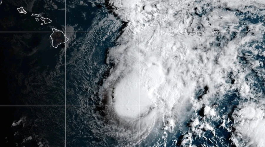
Tropical Storm Moke to Pass South of Hawaii
Cyberzenhub.com – Hawaiian residents are being told to prepare for Tropical Storm Moke to pass south of the island chain within days, delivering a second wave of heavy rain barely a week after Hurricane Lala battered the same terrain. As of the latest tracking data, the system sits approximately 330 miles southeast of Hilo on the Big Island, carrying sustained winds near 45 mph and steering west-northwest at roughly 12 mph. Forecasters expect the storm to retain tropical-storm strength through Tuesday before weakening as it drifts farther from the islands.
Rainfall Outlook by Island
The Big Island bears the brunt of the threat. Meteorologists project cumulative totals of 5 to 10 inches of rain beginning Saturday night and continuing into the following week, with the steepest, highest-elevation terrain potentially receiving up to 15 inches. Satellite imagery from August 22, 2026, already showed rain filtering across portions of the island, and that signal is expected to persist through at least Monday. Lingering showers may still clip select islands as late as Tuesday.
Neighboring islands face a lighter but non-trivial signal: 1 to 3 inches of rain with isolated maxima near 5 inches. On their own those amounts rarely produce catastrophic flooding, yet the context changes the calculus entirely because the ground across the archipelago remains saturated from Lala’s passage just days earlier.
Why the Back-to-Back Sequence Raises the Stakes
Hurricane Lala crossed south of the Big Island on Sunday as a Category 1 system, damaging or destroying more than 100 homes and cutting access to several communities. The governor’s office confirmed that over a foot of rain fell across parts of the state, while the highest elevations logged more than 40 inches. Thousands of Big Island residents were still without electrical power in the days following Lala’s passage.
With soils loosened and drainage channels choked by debris, even moderate rainfall from Moke can ignite life-threatening flooding and mudslides in steep valleys and on slopes that recently absorbed Lala’s heaviest bands. County emergency-management offices have urged residents in those zones to identify evacuation routes now and monitor local alerts continuously.
The Central Pacific basin routinely produces multiple sequential cyclones, with inter-storm spacing as short as five to seven days in an active season. When one system saturates volcanic terrain—sharp ridges, narrow valleys, rapidly erodible cinder-cone slopes—and a second arrives within days, the cumulative hydrological impact far exceeds what either storm would produce alone. For communities still repairing roads, shelters, and power lines after Lala, Moke’s arrival compounds every recovery timeline.
Practical Guidance for Residents
Authorities recommend keeping phones charged, stocking at least three days of water and non-perishable food, and confirming the location of the nearest designated shelter. Those living in low-lying areas or beneath known landslide-prone slopes should be ready to evacuate at a moment’s notice. Watch for rapid rises in stream gauges along the Hilo and Kona watersheds, sustained rainfall exceeding two inches per hour over steep terrain, expanding power outages, and mudslide warnings issued for specific highway corridors.
Forecast models indicate the system will weaken after passing south of the islands, transitioning to a remnant low by midweek. Residual moisture aloft may still feed scattered showers over the chain into Wednesday, keeping ground conditions saturated and delaying full recovery of outdoor activity.
Frequently Asked Questions
When will Tropical Storm Moke affect Hawaii? Rain and gusty winds are expected to reach the Big Island Saturday night and persist into the following week. The storm itself is forecast to pass south of the islands from the weekend into early next week, maintaining tropical-storm intensity through Tuesday.
How much rain should the Big Island expect? Cumulative totals of 5 to 10 inches are projected, with localized maxima of up to 15 inches in the steepest, most elevated terrain. Other islands face 1 to 3 inches with isolated peaks near 5 inches.
Why is this storm more dangerous than a typical tropical system? The ground is already saturated and debris-laden from Hurricane Lala’s passage days earlier. Saturated volcanic soils combined with additional rainfall dramatically increase the likelihood of flash flooding, mudslides, and road failures.
What should residents do right now? Charge phones, stock three days of water and non-perishable food, identify the nearest shelter, and know your evacuation route. Monitor county emergency-management alerts and be prepared to leave at a moment’s notice if you live in a low-lying or landslide-prone area.