
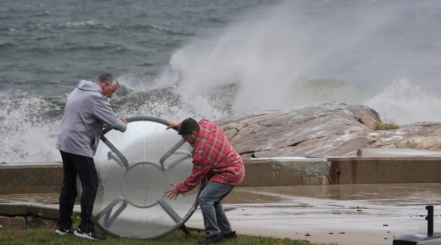
Powerful Nor’easter Puts Northeast Coast on Alert for Rain, Wind and Flooding
Cyberzenhub.com – Communities from the Carolinas to New England are preparing for a significant coastal storm expected to deliver days of rough surf, heavy rain, damaging wind gusts and coastal flooding. The nor’easter is forecast to affect much of the Northeast through the weekend before gradually weakening early next week.
The storm’s hazards are already disrupting plans along the coast. Weekend concerts by Ed Sheeran at Gillette Stadium in Massachusetts have been canceled, along with the Global Citizen Festival in New York City and the Oceans Calling music festival in Ocean City, Maryland. Travelers may also encounter flight delays or cancellations as strong winds spread northward along the East Coast.
Emergency declarations issued in New York and New Jersey
New York Gov. Kathy Hochul declared a state of emergency covering New York City, Long Island and Westchester. Residents in those areas have been urged to remain alert as the storm intensifies.
“Take this storm seriously.”
In New Jersey, Gov. Mikie Sherill declared a state of emergency in eight counties facing the greatest expected effects: Atlantic, Burlington, Cape May, Cumberland, Middlesex, Monmouth, Ocean and Salem.
“Starting tonight, this nor’easter is expected to bring damaging winds, heavy rain, significant coastal flooding, and resulting beach erosion, with these eight counties facing the greatest risk,” Sherill said.
The combination of high surf, persistent onshore winds and elevated water levels poses a particular concern for beachfront communities. Coastal flooding alerts stretch from North Carolina’s Outer Banks north to Maine, with some places facing water levels as much as 3 feet above normal.
Large waves could reshape beaches
Powerful surf is expected to remain one of the storm’s most visible and destructive effects. Waves as high as 19 feet have already been measured near the Outer Banks. From there to the New Jersey shoreline, waves could reach 12 feet through Saturday. Similar conditions are possible along the New England coast into Sunday.
These conditions can accelerate beach erosion, especially where repeated waves strike during periods of high tide. Coastal residents should keep clear of jetties, seawalls and flooded beach access points, where waves and changing water levels can create dangerous conditions even when rainfall has eased.
High surf also affects roads and low-lying neighborhoods near bays, inlets and tidal rivers. Flooding in these locations can occur well away from the open ocean when strong northeast winds push water toward shore for extended periods.
Damaging wind threat extends from the Jersey Shore to Massachusetts
Wind will become more dangerous as the system gains strength and shifts north. A high wind warning is in effect from Friday night through Sunday for the Jersey Shore and coastal areas of Rhode Island and Massachusetts. Gusts could approach 60 mph in the most exposed locations.
New York City may see gusts between 40 and 50 mph from Friday night into Sunday. Such winds can bring down tree limbs, cause scattered power outages and make travel difficult for high-profile vehicles. Residents should secure outdoor furniture, trash containers and other loose items before conditions worsen.
Power interruptions are possible across the region, particularly in coastal areas where saturated ground and repeated wind gusts may make trees more vulnerable. Keeping phones charged, checking flashlights and avoiding downed wires are practical precautions as the storm moves through.
Rainfall expected to build Saturday
Rain is forecast to spread northward Saturday morning, reaching areas from New Jersey through Massachusetts during the day. The nor’easter is expected to be strongest on Saturday, then linger over New Jersey while weakening somewhat on Sunday.
Although rainfall may become less steady Sunday, wet weather is likely to persist across a wide corridor from Washington, D.C., to Maine. The slow movement of the storm means some areas could experience rain over several days rather than receiving all of it in a short burst.
Boston, Rhode Island, coastal New Jersey and Long Island could receive 4 to 6 inches of rain through Monday. A broader area from Delaware to Maine may see 2 to 4 inches. Isolated flash flooding remains possible, though the extended timing of the rain lowers the likelihood of widespread, severe flash flooding.
Drivers should still be cautious around ponding water and flooded streets, particularly near the coast and in poorly drained urban areas. Water can hide road damage and become hazardous quickly when tides are high or drainage systems are overwhelmed.
What makes a nor’easter different
Nor’easters are named for the northeast winds that commonly blow along the coast during these storms. They can form in any season, but they occur most often and can be most intense between September and April.
A classic nor’easter often combines heavy rain or snow with strong winds, rough seas and coastal flooding. The exact impacts depend on the storm track, the timing of high tides and how long the system remains near the shoreline. In this case, the expected persistence of wind and surf is likely to magnify coastal concerns even as the storm begins losing strength.
The system is expected to continue weakening Monday as it moves into New England, with the storm forecast to dissipate Tuesday. Until then, residents and visitors along the Northeast coast should monitor local alerts, prepare for changing travel conditions and avoid unnecessary exposure to flooded roads and hazardous surf.
Related Reading
Frequently Asked Questions
What is Tracking the nor easter?
Tracking the nor easter is the main topic of this guide. The article explains the context, practical details, and next steps readers should understand.
Why does Tracking the nor easter matter?
Tracking the nor easter matters because readers are looking for a useful answer, not just a short summary. Good content should match search intent and help them decide what to do next.