
Nor easter brings strong winds, flooding and high surf East
Cyberzenhub.com – Nor easter brings strong winds, coastal flooding and dangerous waves to communities from Virginia through Maine as the slow-moving storm tracks north off the East Coast. The system was located about 200 miles east of the Delmarva Peninsula Saturday morning, keeping the Mid-Atlantic and Northeast under prolonged hazardous weather conditions.
Strong winds, periods of heavy rain and repeated high-tide flooding are expected to continue through the weekend. Although the storm is forecast to weaken Sunday, coastal impacts and gusty weather could linger into Monday in some areas.
Damaging Wind Gusts Hit the Jersey Shore
Wind gusts were already severe late Friday night. A weather station in Surf City, New Jersey, recorded a 74 mph gust, while several other Jersey Shore locations reported gusts exceeding 60 mph.
High wind warnings remain in effect for the Jersey Shore and parts of Rhode Island and Massachusetts, including Atlantic City, Providence and Boston. Gusts could reach 60 mph, raising the risk of falling trees, downed power lines, power outages and hazardous travel.
Wind advisories stretch farther inland, from the Delmarva Peninsula to eastern Massachusetts. Dover, Philadelphia, New York City, Hartford and Worcester could experience gusts up to 45 mph.
Nor easter brings strong winds well beyond the immediate coastline, where wind-driven rain and saturated ground can make trees and utility infrastructure more vulnerable. Residents should secure outdoor objects and use caution around branches, power lines and debris.
Flooding Risk Increases Around High Tide
Coastal flood alerts cover areas from eastern Virginia to southern Maine, including Virginia Beach, Philadelphia, New York City, New London, Providence and Boston. The greatest concern is near bays, inlets, tidal rivers and low-lying shoreline roads.
Flooding reached moderate levels late Friday before water began rising again ahead of Saturday morning’s high tide, expected near 8 a.m. Moderate to major coastal flooding is possible from the southern Chesapeake Bay through the Jersey Shore and toward Raritan Bay.
A second high tide near 9 p.m. Saturday could bring another round of flooding. Minor to moderate flooding is possible along parts of the Chesapeake Bay, the Delaware River and southern coastal New England, while isolated major flooding remains possible in especially vulnerable locations.
Drivers should never attempt to cross flooded roads. Saltwater can hide damaged pavement, move debris into roadways and leave dangerous conditions behind even after water levels begin to fall.
High Waves Bring Erosion and Surf Hazards
Buoys off the Jersey Shore and southern New England recorded waves of at least 16 feet. Coastal waves of 6 to 12 feet or higher are expected from Delmarva through New Jersey, Long Island and southeastern New England.
The heavy surf could cause widespread beach erosion and damage in exposed coastal areas. Jetties, piers, seawalls and beaches may be particularly dangerous as large waves and strong currents continue through the weekend.
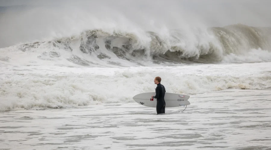
Surfers were seen at Rockaway Beach in New York City on September 25, 2026, as the storm approached, but officials urge caution near the water. Nor easter brings strong winds and rapidly changing surf conditions that can make recreation along the coast especially risky.
Rain Continues Across the Northeast
The strongest winds Saturday morning are expected from the Jersey Shore into southeastern New England, where gusts of 50 to 60 mph or greater are possible. Heavy rain is also expected from Maryland into New Jersey and southern New York.
By Saturday afternoon and evening, rain and gusty winds are expected to continue from Maryland to southern New York and expand into southern New England. Repeated rain bands may persist overnight into Sunday morning.
Local FAQ: Staying Safe During Coastal Storm Conditions
When is coastal flooding most likely?
Flooding is often most severe around high tide. Check local tide timing, weather alerts and road closures before traveling near shorelines, tidal rivers or waterfront neighborhoods.
Should I drive through standing water?
No. Avoid flooded roads and turn around when water covers the pavement. Coastal flooding can deepen quickly and may conceal debris or road damage.
What should residents do during high winds?
Bring in or secure outdoor items, stay clear of trees and downed wires, and prepare for possible power outages. Keep phones charged and follow instructions from local emergency officials.
Related Reading
Frequently Asked Questions
What is Nor easter brings strong winds coastal?
Nor easter brings strong winds coastal is the main topic of this guide. The article explains the context, practical details, and next steps readers should understand.
Why does Nor easter brings strong winds coastal matter?
Nor easter brings strong winds coastal matters because readers are looking for a useful answer, not just a short summary. Good content should match search intent and help them decide what to do next.