
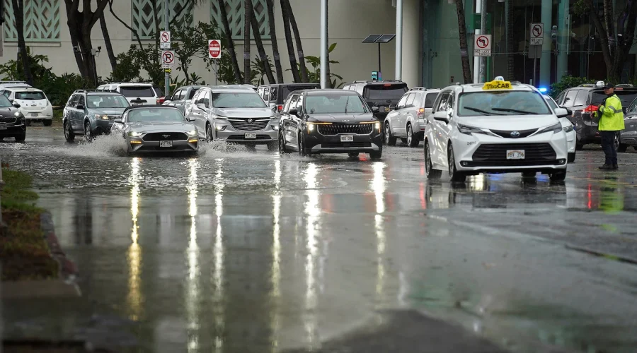
Tropical Storm Moke Threatens Hawaii
Cyberzenhub.com – Tropical Storm Moke develops as Hawaii’s Big Island prepares for a second wave of torrential rain just days after Hurricane Lala tore through the island. With soils already waterlogged from Lala’s passage, forecasters warn that the added precipitation from Moke dramatically elevates flood and landslide danger across the island’s steep volcanic terrain. The storm, which reached named-storm status Friday with sustained winds near 45 mph, is tracking south of the island and is expected to deliver its most intense rainfall between Sunday and Monday morning.
What the Forecast Shows
Rain bands from the system are projected to overspread the island’s southern slopes as early as Saturday night, with the core’s closest approach driving the heaviest downpours on Sunday and sustained heavy rain continuing into Monday. Forecast totals for the Big Island range from 5 to 10 inches, with localized peaks of roughly 15 inches in the highest elevations. The remainder of the Hawaiian chain is expected to receive 1 to 3 inches over the weekend, with isolated maxima near 5 inches — enough to overwhelm urban drainage and trigger flash flooding in low-lying coastal zones.
These rainfall figures place the event squarely in the range where rivers breach their banks, roadways become impassable, and hillsides lose structural cohesion. For communities still clearing Lala debris and waiting for power restoration, the preparation window is narrow and shrinking.
Why Saturated Ground Changes Everything
Hydrologists stress that flood severity depends as much on ground condition as on rainfall intensity. Lala deposited more than a foot of rain across portions of the state, with the highest elevations receiving over 40 inches. Soils on the Big Island are now at or near full saturation, meaning infiltration capacity has collapsed. Water that would normally percolate into the ground instead runs off rapidly, accelerating stream gauges, overloading culverts, and adding lethal weight to steep volcanic slopes already stripped of stabilizing vegetation by hurricane-force winds.
When a second storm arrives on saturated terrain, the landscape essentially stops absorbing water. Every additional inch becomes surface runoff — and on volcanic slopes, that runoff becomes a debris flow.
Areas that sustained direct Lala damage face compounded exposure: roads weakened by erosion, drainage channels clogged with debris, and hillsides with stripped vegetation all reduce the landscape’s capacity to slow the next round of precipitation. Forecasters have specifically flagged steep terrain and previously impacted zones as highest-priority evacuation and monitoring areas.
Lala’s Aftermath Remains Unresolved
Hurricane Lala crossed south of the Big Island on Sunday as a Category 1 hurricane, leaving more than 100 homes damaged or destroyed and several communities cut off as roads washed out or buried under debris. Thousands of residents remained without electrical power in the days following Lala’s passage, complicating refrigeration, communications, and emergency readiness for the new threat. The governor’s office confirmed that recovery operations were still underway when Moke’s forecast track became clear, stretching emergency-management resources and compressing the window residents have to secure property, relocate vehicles, and reach higher ground.
Practical Steps for Residents
The most critical preparation window falls between Friday evening and Saturday night, before overspreading rain begins. Residents in low-lying areas, near stream corridors, or on steep slopes should review evacuation routes, identify higher-ground shelters, and ensure vehicles are fueled and parked on firm, elevated surfaces. Those still dealing with Lala damage should prioritize moving medications, documents, and valuables to upper floors or designated safe rooms. Because utility outages from Lala may leave some neighborhoods without reliable power, battery-powered radios, flashlights, and portable chargers are essential. Monitor official channels continuously for evacuation orders, as compromised roadways may force preemptive evacuations before the worst rain arrives.
Frequently Asked Questions
When will the heaviest rain hit the Big Island? Forecasters project peak rainfall between Sunday and Monday morning, with overspreading rain bands arriving as early as Saturday night.
How much rain is expected? The Big Island is forecast to receive 5 to 10 inches, with localized maxima near 15 inches in the highest terrain. Other islands in the chain are expected to get 1 to 3 inches, with isolated peaks around 5 inches.
Why is this storm more dangerous than a typical tropical system? Because Lala already saturated the ground, Moke’s rainfall will produce far more surface runoff than the same amount of rain would on dry soil, sharply increasing flood and landslide risk.
What should I do if I am still recovering from Lala damage? Prioritize moving essential items to higher ground, fuel your vehicle, keep a battery-powered radio and flashlight accessible, and monitor official channels for evacuation orders. Do not wait for rain to begin before acting.