
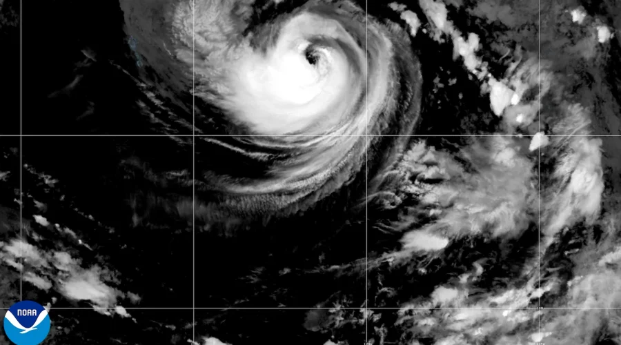
Pacific Cyclone Karina Reaches Hurricane Status as Forecasters Eye Potential for Major-Storm Intensity
Cyberzenhub.com – The open waters of the eastern Pacific gained a new hurricane on Sunday when Tropical Storm Karina crossed the 74-mph threshold and officially became a Category 1 hurricane. Though the system sits hundreds of miles from any coastline, forecasters at the Miami-based National Hurricane Center flagged the possibility that Karina could intensify further during the coming days, potentially reaching Category 3 strength or beyond — the threshold at which a storm is classified as a “major” hurricane.
At the time of the latest advisory, Karina’s maximum sustained winds had climbed to 80 mph (130 km/h), placing it firmly in the lowest tier of hurricane classification. The storm’s center was positioned roughly 820 miles (1,325 kilometers) southwest of the southernmost tip of Mexico’s Baja California Peninsula, deep in open ocean. It was tracking northwest at approximately 15 mph (24 km/h), a trajectory that carries it progressively farther away from landmasses rather than toward them.
What “Major Hurricane” Means and Why It Matters
In the Saffir-Simpson Hurricane Wind Scale used across the Atlantic and Pacific basins, hurricanes are divided into five categories based on sustained wind speed. Category 1 spans 74–95 mph, Category 2 covers 96–110 mph, and Category 3 begins at 111 mph. A storm must sustain winds of at least 111 mph (177 km/h) to earn the “major” designation. While a Category 3-plus event in the open Pacific rarely makes headlines the way an Atlantic landfall does, the distinction matters to oceanographers, shipping operators, and Pacific-island communities that occasionally feel the outer bands of such systems.
For the general public, the more immediate concern tied to Karina is not wind but water. Even storms positioned well offshore generate long-period swell trains that propagate across hundreds of miles of ocean. The hurricane center warned that these swells were likely to produce dangerous surf and rip-current conditions along stretches of southwest Mexico’s coastline and the Baja California Peninsula. Rip currents — narrow channels of water flowing steadily away from shore — remain the leading cause of drownings at surf beaches worldwide, and their intensity scales with the size and duration of incoming swell. Beachgoers in those regions were advised to check local surf reports and heed posted warnings through the remainder of the week.
A Second Pacific System: Tropical Storm Lowell
Not far from Karina’s general region of activity, another tropical system was also tracking through the central Pacific. Tropical Storm Lowell sat approximately 1,150 miles (1,850 kilometers) southeast of the Hawaiian Islands at the time of reporting. Like Karina, Lowell posed no direct threat to populated areas and was expected to remain over open water. Its presence, however, underscores the fact that the Pacific basin can host multiple tropical cyclones simultaneously, each drawing energy from warm sea-surface temperatures and favorable upper-level wind patterns.
Atlantic Outlook: El Niño Tilts the Season Toward Below-Average Activity
While Pacific activity draws attention this week, the broader seasonal picture for the Atlantic basin points in the opposite direction. The National Oceanic and Atmospheric Administration (NOAA) has issued its seasonal outlook projecting a below-average Atlantic hurricane season, a forecast driven largely by the presence of El Niño conditions in the tropical Pacific. El Niño strengthens upper-level wind shear over the Atlantic, which tends to tear developing storms apart before they can organize into hurricanes.
Under the NOAA scenario, the season is expected to produce between eight and 14 named storms. Of those, three to six are projected to reach hurricane strength (sustained winds of 74 mph or higher), and one to three are anticipated to intensify into major hurricanes (Category 3 or above). For comparison, a typical Atlantic season averages around 14 named storms, six hurricanes, and three major hurricanes. The El Niño-modified forecast thus represents a meaningful reduction in expected activity, offering a measure of relief to coastal communities from the Carolinas through the Gulf of Mexico and the Florida peninsula.
Practical Implications for Readers
For residents and visitors along Mexico’s Pacific coast and Baja California, the actionable takeaway from Karina’s current track is straightforward: expect elevated surf, stronger-than-usual rip currents, and potentially rougher-than-normal conditions at popular swimming and surfing spots for several days. Local lifeguard stations and municipal authorities in those areas typically issue beach advisories when swell heights exceed certain thresholds, and heeding those advisories is the single most effective step to reduce drowning risk.
For those following the Atlantic season, the El Niño signal embedded in NOAA’s outlook suggests a quieter-than-typical year ahead. That does not eliminate risk entirely — even below-average seasons have produced devastating landfalls — but it does shift the statistical odds in favor of fewer and weaker storms reaching the U.S. coastline. Meteorologists caution that seasonal forecasts carry wide uncertainty ranges and that individual storm tracks remain unpredictable until days before landfall.
As Karina continues its northwestward drift into increasingly open Pacific waters, forecasters will continue monitoring its intensity and structure. Should the system strengthen to Category 3 or above, it would join a small number of Pacific major hurricanes that form far enough offshore to never threaten land, serving as reminders that the ocean’s most violent weather often plays out beyond the reach of any coastline.
Related Reading
Frequently Asked Questions
What is Tropical Storm Karina strengthens into a hurricane?
Tropical Storm Karina strengthens into a hurricane is the main topic of this guide. The article explains the context, practical details, and next steps readers should understand.
Why does Tropical Storm Karina strengthens into a hurricane matter?
Tropical Storm Karina strengthens into a hurricane matters because readers are looking for a useful answer, not just a short summary. Good content should match search intent and help them decide what to do next.