
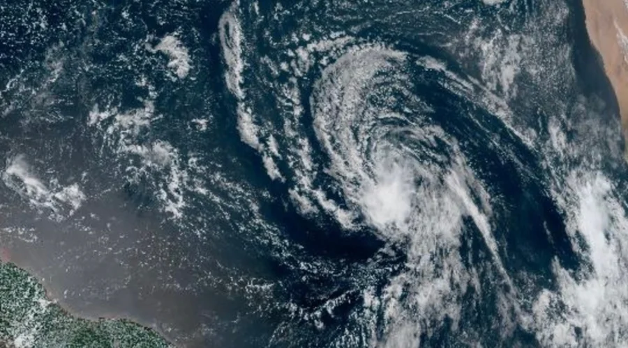
Fourth Named Storm of 2026 Season Takes Shape in the Atlantic
Cyberzenhub.com – The Atlantic basin gained its fourth named storm of the 2026 hurricane season on Thursday when Tropical Storm Dolly organized over open water, confirmed by the National Hurricane Center. At the time of its designation, the system carried sustained winds of 40 miles per hour and was tracking westward at roughly 24 miles per hour, a pace that would carry it toward the Caribbean basin over the following days.
The storm’s forecast track, as outlined by forecasters, projects that Dolly will hold near its current intensity for a short period before gradually losing structure and ultimately dissipating into a tropical wave — a broad band of low-level moisture and thunderstorm activity that no longer qualifies as a discrete cyclone. That transition is expected to occur as the system approaches the Leeward Islands late this weekend.
What Residents of the Leeward Islands Should Expect
The Leeward Islands — a geographic grouping that encompasses the U.S. Virgin Islands, the British Virgin Islands, Puerto Rico, and the island of Hispaniola (shared by the Dominican Republic and Haiti) — could begin receiving heavy rainfall associated with the remnant of Dolly from late Saturday into Sunday. Forecasters flagged the possibility of flash flooding, particularly in elevated terrain where runoff channels concentrate quickly and drainage infrastructure is limited.
For communities in Puerto Rico, the Virgin Islands, and the mountainous interior of Hispaniola, even a weakening tropical system can deliver several inches of rain in a compressed window. The terrain amplifies the hazard: steep slopes accelerate water flow, and narrow valleys can see stream levels rise within minutes. Residents in those zones are advised to monitor local emergency-management alerts through the weekend and avoid low-lying drainage corridors after sustained rainfall begins.
The Naming Convention and a Coincidental Tribute
The name “Dolly” carries no connection to the late country-music icon Dolly Parton, who passed away earlier this week following a brief battle with cancer. The coincidence drew public attention, but the National Hurricane Center assigns storm names on a rotating six-year list that is finalized years before any given season begins. In other words, “Dolly” was already locked into the 2026 roster long before the singer’s passing made the name newly resonant in popular conversation.
Under the current naming cycle, the name Dolly will not reappear on an Atlantic list until 2032. Each name in the six-year rotation is retired from active use for five full seasons before it cycles back, a practice designed to reduce confusion in public communications and archival records.
Seasonal Context: A Below-Normal Outlook
Dolly’s formation places the 2026 Atlantic season at four named storms, a pace that sits within the range NOAA has maintained for a below-normal season. The agency’s seasonal outlook, issued in advance of hurricane season, projects fewer-than-average named storms, hurricanes, and major hurricanes for the basin this year. A below-normal forecast does not eliminate the risk of individual storms producing significant impacts; it simply indicates that the overall statistical probability of a high-activity season is reduced.
For readers unfamiliar with the terminology: a “tropical wave” is a disturbance in the easterly trade winds that often serves as the seed from which tropical cyclones develop. When a storm “dissipates into a tropical wave,” it means the organized circulation breaks down and the system reverts to a broader, less structured band of moisture. The rain potential does not vanish entirely, which is why forecasters still issue rain warnings for areas in the path of the remnant wave.
Why the Distinction Matters
The difference between a named tropical storm and its post-dissipation tropical-wave phase is practical as well as meteorological. A named storm triggers specific advisory protocols — coastal watches, wind-speed thresholds, and public messaging calibrated to organized circulation. Once the system degrades, those protocols shift toward rainfall and flash-flood guidance, which is the primary residual hazard for the Leeward Islands this weekend.
Forecasters emphasized that while Dolly’s winds will not threaten coastal areas with hurricane-force gusts, the rain band associated with its remnant circulation can still produce localized flooding severe enough to close roads, overwhelm urban storm drains, and trigger small-scale landslides in hilly terrain. The message for residents of Puerto Rico, the Virgin Islands, and Hispaniola is straightforward: treat the weekend rain as a genuine flood risk, not a benign afterthought of a storm that has already lost its name.
The National Hurricane Center will continue issuing updates as Dolly’s remnants traverse the Caribbean basin. No landfall of an organized tropical cyclone is projected for any populated area during this event.
Related Reading
Frequently Asked Questions
What is Tropical Storm Dolly forms in the Atlantic?
Tropical Storm Dolly forms in the Atlantic is the main topic of this guide. The article explains the context, practical details, and next steps readers should understand.
Why does Tropical Storm Dolly forms in the Atlantic matter?
Tropical Storm Dolly forms in the Atlantic matters because readers are looking for a useful answer, not just a short summary. Good content should match search intent and help them decide what to do next.